NEW ARRIVAL
-
Windows Software
Stonex GeoGis is a powerful yet simple software solution for the collection of high quality feature and position data for GIS update and maintenance. GeoGis software provides simple and efficient workflows to capture high quality data quickly and easily. GeoGis is an option that can be embedded into handheld GIS systems. GeoGis is developed for Windows Mobile.
-
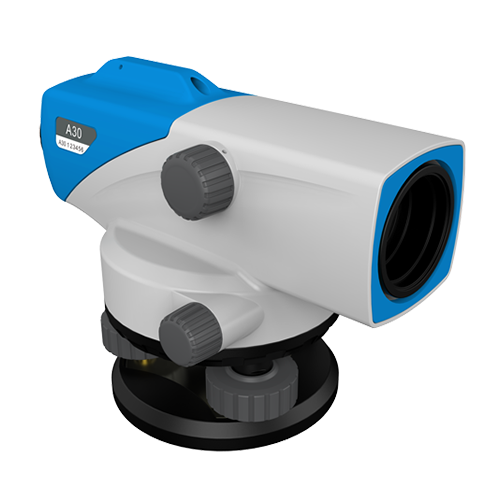
Auto Level with the highest performances for easy measurements in any construction and survey applications. Stonex brings the benefits of Auto Level to construction applications at an affordable price with the reliable, easy-to-use A30 Auto Level. The Stonex A30 Auto Level minimizes human error and maximizes the ease of levelling work, allowing increased productivity and performance. In few seconds height difference and distance can be measured. A30 guarantees high accuracy with ±1.5mm standard deviation of 1km round-trip leveling measurement. The compensator of the Stonex A30 has minimal thermal expansion coefficient, providing unmatched durability and accuracy. Error reducing functions, such as the tilt sensor prevent the system from measuring if the user operates outside the compensator range. Multiple reading for horizontal angles available ( 1° or 1gon ). Any angle can be read thanks to the free rotation characteristics. The Stonex A30 Auto Level is the perfect instrument for your daily levelling tasks.
-
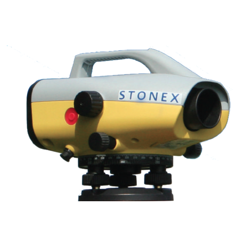
DESCRIPTION
To use together with a barcoded stadia for high precision measurements, the Digital Level D2 provides an height accuracy of 0,7mm/Km. This makes the D2 an ideal level not only for high order levelling but also deformation measurements and precise surveying, as well as general construction. The onboard adjustment program, height difference calculator, inverse staff measuring mode, in combination with various measuring configurations enable you to execute all calculation.
Key Features:
- The internal memory can store up to 2000 measures (points) that can be downloaded on a computer by an RS232 serial port
- Easy to transport
- Water and dust protected and allow long operation on field (about 16 hours).
- The right solution for measure gradients or height precision GPS systems
-
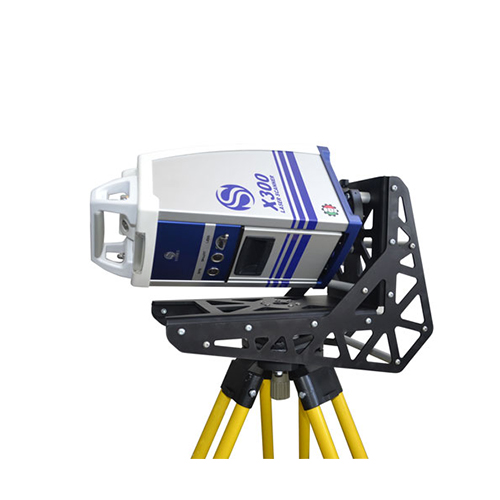
X300 Framework for 90° tilted scanning (with Trolley Carrying Case)
X300 Framework is a Stonex X300 Laser Scanner support accessory useful for scanning closed environments such as caves, architectural structures and tunnels, where ceilings are particularly high.
This accessory allows the scanner to perform a full scan with a vertical field of view of 240° (the scan also covers the surrounding walls and part of the underlying surface).Thanks to X300 Framework it is possible now to shorten both time of work in the field and the time of post-processing, because the number of scans required is reduced.
-
Simple, Tough, Accurate
STONEX X300 is a 3D Scanner designed to deliver effective results every day, on any project. It’s ease of use, reliability, flexibility and reasonable price make it your perfect work companion.
-
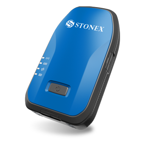
GNSS Receiver for GIS & RTK Applications
Compared to traditional GIS products, the S500 is an intelligent, high precision data acquisition receiver that can be used without the need to hold it in your hand and therefore offers greater freedom of movement and flexibility.
Thanks to the internal web interface, the receiver can be configured and prepared to receive RTK differential corrections and ready to be connected to any software for Survey or GIS.
The S500 offers high-precision positioning and is equipped with a high speed 4G module. The positioning is so fast and reliable that it can also be used by vehicles moving at high speed. S500 works with all 4 satellite system (GPS, Glonass, BeiDou, Galileo), support access to external differential RTK signal to get centimeter level positioning results.
Rubber protective cover, increase the protection of the device, non-slip and no damage, the whole device protective class reaches IP67, and it resists 1.2m hard ground drop. -
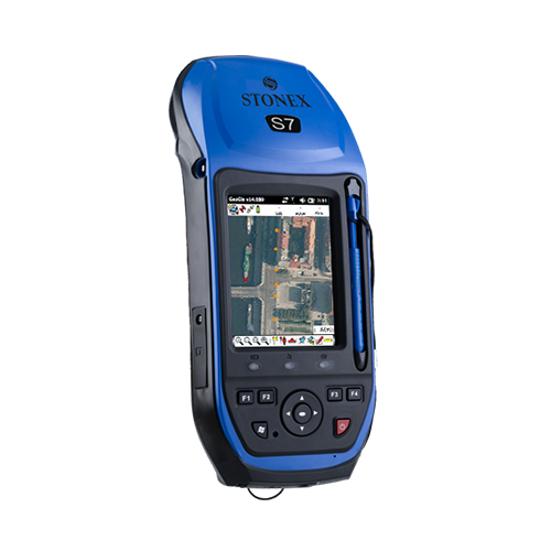
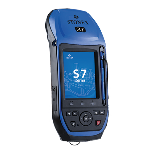
GNSS handheld receiver for modern positioning technology
GIS & SURVEY in one solution
STONEX S7G GNSS receiver combine the modern positioning technology and versatility of a powerful handheld, perfect for collecting geographic data and operate fast and accurate measurements.
S7G handheld is compact, ergonomic and small size and weight: 234 mm x 99 mm and 895g. S7G is powered by a Cortex-A8-AM33X 1GHz processor and Windows Mobile 6.5 Professional operating system. To increase performance and to load the job data is available an SD card slot for external memory (internal 32 GB is included). S7G integrate a GSM/GPRS modem that provides fast and efficient internet connection directly on the field, and Wi-Fi and Bluetooth technology, that allow the user to transfer data quickly and conveniently on long distances.
Thanks to the 3G internal modem there is also the possibility to improve the accuracy of data, connecting to real time differential correction network provider. -
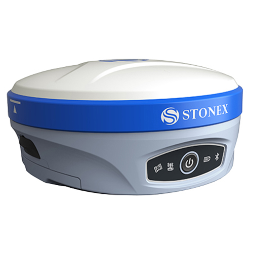
Powerful Precision & High Frequency
S900T is the result of the continuous evolution of the Stonex GNSS integrated receivers.
Featuring a new, high accuracy multi constellation antenna, a powerful UHF transmitter and the GSM 4G modem, for a fully integrated communications choice, combined with a light and modern design.
Stonex S900T integrated GNSS receiver tracks all the present constellations and satellite signals GPS, GLONASS, BEIDOU, GALILEO and QZSS and through the upgradable firmware offers the opportunity to be day by day updated with the latest available features.
On S900T it is possible to insert 2 smart hot swappable batteries at the same time, ensuring a maximum of 12 hours of operation without stopping.
The power level can be checked and seen on the controller or directly on a led bar on the battery. Moreover, the same battery is used on S900T and on the Stonex controllers S4II C/H.
UPCOMING EVENTS
Fieragricola 2020
VERONA | 29 GENNAIO – 1 FEBBRAIO 2020
Stonex sarà presente come espositore a Fieragricola 2020 a Verona. Fieragricola è un appuntamento imperdibile per il settore agricolo. Nata nel 1898, Fieragricola festeggerà nel 2018 i 120 anni di storia, con una formula rivolta a tutte le specializzazioni del settore agricolo: meccanica agricola, vigneto e frutteto, zootecnia, energie da fonti rinnovabili, multifunzione, gestione del verde e attività forestale, agrofarmaci e fertilizzanti.
Dalla A di agricoltura alla Z di zootecnia. Ecco i punti chiave da non perdere durante la manifestazione e le attesissime novità dell’edizione 2020.

ABOUT OUR COMPANY
Headquartered on the outskirts of Milan, Italy, Stonex is one of the world leader company on measurement and survey, with over 80 qualified distributors worldwide.
Thanks to the integration of different positioning technologies and software the wide range of solutions allows to meet the needs of many fields of application and industries, such as Building and construction, Land survey, GIS and cadastral survey, 3D Scanning, Agricolture and smart farming.
Joined together with an unbeatable professional expertise Stonex offers a wide range of top quality services, to satisfy all pre-sales and post-sales needs.
Stonex is a part of Beijing UniStrong Science & Technology Co., Ltd, global provider of GNSS, positioning and timing technology for the geospatial market.